In the northern of the Seine-Maritime department lies the Forêt d’Eu which stretches in various groves from the town of Eu all the way to Aumale. La Bresle, a marshy valley which offered good protection against invaders with the Forêt d’Eu on its left bank acted in theory as the border between the Duchy of Normandy and the kingdom of France. Numerous fortified castles were scattered along this valley (Eu, Monchaux, Brétizel, Aumale) and towards the valley of L’Epte (Neuf-Marché, Château-sur-Epte, Dangu, Gisors…) which formed the first line of defense. More to the South, other castles formed a second line of defense : Le Bel/Criel, Foucarmont, Pontrancart/Ancourt, Wanchy, Mortemer, Neufchâtel/Drincourt, Beaussault, Gaillefontaine, Saint-Saëns, Bellencombre, Torcy-le-Grand, Arques, Dieppe, Bracquemont… (Check the section Les châteaux du Talou / The castles of Talou)..
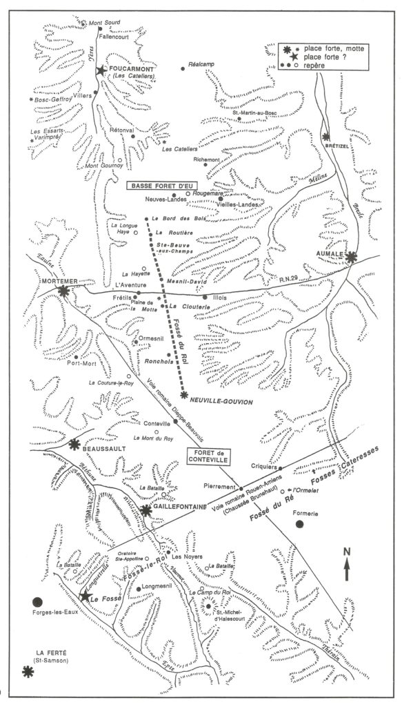
However, this border had a weak point between the Basse Forêt d’Eu and the ancient Forêt de Conteville which is just a wood today. That is precisely where was built Le Fossé du Roi (The King’s Moat) which enhanced the defense system of the borders of Normandy. This system was established during the last years of the 11th century and the first third of the 12th century and was structured around a string of fortresses.
Twelve kilometers long and still clearly visible in some areas, it stretches on a ridge between the upper basin of La Bresle and the high valleys of the rivers, L’Yères, L’Eaulne and La Béthune. In the North, by Bord-des-Bois (part of Caule-Sainte-Beuve), it leans on the imposing Forêt d’Eu which in the 11th century had not yet been cleared, and in the South, it reaches the catel of La Neuville-Gouvion (part of Conteville) where one can still see the upper bailey around a moat of more than 30 meters in diameter at the top. It seems a military element of the Duchy of Normandy, established sometime between 1066 and 1130.
Les Fossés du Roi (The King’s Moats) also known as Fossé-le-Roi, Fossé du Ré… encircled in fact all of Normandy all the way to the the Mont-Saint-Michel in South Normandy.
Source : Gaudefroy Ghislain et Lionel. L’énigme du Fossé du Roi, section d’une ligne de défense ceinturant le duché de Normandie ? Les cahiers de la Société Historique et Géographique du Bassin de l’Epte, S.H.G.B.E., Le Coudray-Saint-Germer, n°35, 1995, pp. 30-62.

between the Basse Forêt d’Eu and the ancient Forêt de Conteville
